The Advantages of Drone Mapping in Environmental Impact Assessments
Environmental impact assessments are a crucial part of many development projects, from infrastructure to mining to energy production. These assessments help identify the environmental impacts of a project and develop strategies to minimise or mitigate those impacts. Traditional methods of conducting environmental impact assessments can be time-consuming and expensive and may not provide the level of detail needed to fully understand the potential impacts of a project.
Fortunately, drone mapping and orthomosaic photos are revolutionising the way environmental impact assessments are conducted. These technologies offer a faster, more accurate, and more detailed way to collect data about the environment, and are quickly becoming an essential tool for planning consultants, environmental consultants, and others involved in environmental impact assessments.
What is Drone Mapping?
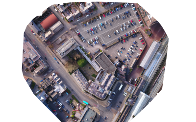
Drone mapping is the process of using drones to capture aerial images of a specific area. These images can then be stitched together to create a detailed, high-resolution map or model of the area. Drone mapping has become increasingly popular in recent years thanks to advances in drone technology and the development of sophisticated mapping software.
Importance of GSD
There are several factors to consider when using drones to map and area, one of the most important is GSD or Ground Sample Distance. The GSD represents the distance between two consecutive pixel centers on the ground, and directly affects the level of detail captured in the image. It is crucial to ensure the GSD is appropriate for the intended use of the map. The GSD should be small enough to capture the required level of detail, but not so small that it creates an unnecessarily large file size or a longer processing time.
The GSD required depends on the sensor size, altitude and the terrain of the area being mapped. For example, if the area has varied terrain, then a smaller GSD may be required to capture all of the features. In contrast, if the area has more homogenous terrain then a larger GSD may suffice. We can help you determine the appropriate GSD for your specific project requirements. Working with a drone mapping expert will ensure the resulting orthomosaic is both accurate and detailed enough for your specific project requirements.
How Drone Mapping is Used in Environmental Impact Assessments
One of the key advantages of drone mapping in environmental impact assessments is the ability to collect data more efficiently and accurately than traditional methods. Drones can cover large areas quickly and easily, and can capture data from hard-to-reach locations like steep slopes or bodies of water.
With drone mapping, it’s possible to collect a wide range of data, including topography, vegetation, hydrology, and more. This data can then be used to create detailed 3D models of the environment, which can be used to analyse potential impacts of a development project.
For example, a drone can be used to capture data about the vegetation in an area. This data can then be analysed to identify the presence of threatened or endangered species, or to determine the overall health of the ecosystem. Similarly, a drone can be used to capture data about water quality, which can help to identify potential impacts of a development project on aquatic ecosystems.
A big advantage of drone mapping is allowing targeted data collection, which can result in significant cost savings. Rather than sending personnel to walk the entire site, drone mapping can identify specific areas of interest that require further reporting. This targeted approach allows personnel to focus their efforts on specific areas, rather than covering the entire site. As a result, costs can be reduced by minimising the time and resources required for data collection. This can ultimately lead to more efficient environmental impact assessments, as well as cost savings for developers and project owners.
Benefits of Using Drone Mapping in Environmental Impact Assessments
There are several key benefits to using drone mapping in environmental impact assessments:
- Cost-effective: Drone mapping is often more cost-effective than traditional methods of collecting data, as it requires fewer personnel and can cover large areas quickly and efficiently.
- Efficient: Drone mapping can cover large areas quickly and efficiently, reducing the time and effort required to collect data for an environmental impact assessment.
- Accurate: Drone mapping can capture data with a high degree of accuracy, providing a detailed and reliable source of information for environmental impact assessments.
- Detailed: Drone mapping can provide a level of detail that is often difficult to achieve with traditional methods, allowing for a more nuanced understanding of the environment and potential impacts of a development project.
Conclusion
Drone mapping and orthomosaic photos are revolutionising the way environmental impact assessments are conducted. These technologies offer a fast, accurate, and cost-effective way to collect data about the environment, and are quickly becoming an essential tool for planning consultants and environmental consultants. If you’re involved in environmental impact assessments, it’s worth considering the benefits of drone mapping and how it can help you collect the data you need to make informed decisions about development projects.
Written by Toby Hope
Managing Director of Airtech Images Ltd


